


|
|

Copyright 1996-2004, Todd Murray - tam@visi.com.
 Here
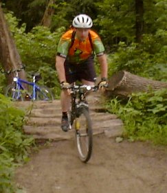
I am riding over a pile of logs on the Minnesota River Bottoms trail.
Here
I am riding over a pile of logs on the Minnesota River Bottoms trail.
I used to be a road bike person and thought that most people who bought mountain bikes just bought them to show them off, instead of riding off the road. I never thought that I'd end up on a mountain bike. Now, as if urged by Darth Vader, I've joined the dark side.
In my case, my conversion to mountain biking took place innocently enough: I bought the book Minnesota Bike Atlas (which I recommend) at a local store. The back section has some mountain bike trails rated by difficulty. I tried the Tierney's Woods trail and the Fort Snelling South trail on my hybrid bike, and I liked them a lot. I enjoyed the whole experience of off-road biking and seeing interesting sights without having 8000 cars around. Then I went out to Lake Tahoe on vacation and biked on the Powerline, General Creek, McKinney-Rubicon, and Flume trails. I couldn't escape it -- I was hooked. So, I bought a Specialized Rockhopper FS mountain bike. Then, I upgraded to a Specialized Stumpjumper Comp. I'm now riding a Specialized Epic Marathon, with probably the most innovative full suspension system I've seen. (Okay, Specialized, pay up.)
Here are some mountain bike trails I've been on and that I can recommend:
Click here to get to more links about mountain biking.
Disclaimer: Mountain biking is more dangerous than biking around Lake Calhoun. Wear a helmet if you think you have anything worth protecting in there. Follow the IMBA rules of the trail . And remember: if you're scared, stay home.
Since the counter crashed on 2/16/98,
people have seen this page.
Getting there: There used to be an access to this trail from the Old Cedar Avenue Bridge
in Bloomington, but the bridge has since been closed.
In Eagan, take Highway 13 east past Highway 77 and turn left (north) on
Nicols Road. Follow it until you see the parking lot for the boat ramp.
(Note: This access point requires a State Parks daily permit or yearly sticker. They aren't sold on site -- you have to go to the main entrance of Fort Snelling State Park at Highway 5 and Post Road.) Follow the biking/hiking trail out of the woods, which becomes a doubletrack trail and then returns to the riverside. The trail continues for about 7.5 miles up to a short distance past the Mendota Bridge.
I believe there is also an access point from behind the Sibley House Historic
Site in Mendota, and there is a parking lot along Highway 13.
Difficulty: Beginner; about 2/3 doubletrack and 1/3 singletrack. Mostly flat terrain.
Pluses: A good beginner route, although it wouldn't completely bore more experienced riders. I like to stop directly under the airport's flight paths and watch planes come in just a few hundred feet overhead, like the scene in Wayne's World.
Minuses: Bring mosquito repellent (this goes for any area along the Minnesota River). You'll get bitten anyway, but I told you so. There is often standing water on the trail draining from the railroad grade near the Mendota Bridge.
Getting there: There are several locations to get onto the trail.
The western end is at the old Bloomington Ferry Bridge on the north side
of the river. There is now a parking lot at the end of the bridge.
You can also get onto the trail from the southern end of Normandale Boulevard (by the former MN&S railroad swing bridge)*, the southern end of Lyndale Avenue, or from Indian Mounds Elementary School. (This is as good an entrance as any. Take Old Shakopee Road/98th Street east from Highway 35W. Turn right on Columbus Ave., then left onto 99th St. to 11th Ave. S. Park near the school, then follow 11th Avenue south. The trail starts on the left.)
*My friend Todd would like it known that the swing bridge is still in operation,
owned by the Twin Cities and Western Railroad, and serves grain elevators
south of the river.
The eastern end of the trail starts at the end of the old Cedar Avenue Bridge (see the directions for Fort Snelling South, but take a right just before you get into the river and follow the singletrack.) The eastern section, between Cedar Avenue and Indian Mounds Elementary, is more tricky because it has several sand dunes and a few places where you need to duck under trees.
Difficulty: Intermediate; mostly singletrack in the forest with several jumps and a few obstacles. Can be muddy after a rain.
Pluses: This is a nice challenging trail with good views of the river. You should be able to see at least one deer in the forest.
Minuses: Bring mosquito repellent again. A few areas, especially west of the railroad bridge, are always muddy unless it hasn't rained for a month.
Special Note: The Minnesota Department of Natural Resources has proposed to pave this trail to match all of the other rails-to-trails projects around the state. If you think this is a dumb idea, as I do, then call the DNR or your elected officials to complain. Good singletrack can't be lost!
Links: City of Bloomington - Bloomington Briefing, Bloomington Parks & Recreation
I've posted property ownership maps of the Minnesota River Bottoms trail in Bloomington, mainly for some people who asked me for those maps at a meeting. Click here for access to those maps.
This is one of the hot spots for mountain biking in the Twin Cities. This is a good, challenging singletrack trail in the middle of a forest with plenty of sharp, twisty curves, several hill climbs, and some wild descents. Unfortunately, it's closed from October 15 through May 1.
Getting there: Take Burnsville Parkway east from Highway 35W past County Road 11. The park is on your right. The mountain bike entrance is on Burnsville Parkway about 1/3 mile east of County Road 11. (Note that the west entrance is not open to mountain bikers.) There are signs that indicate where the trail is, along with maps.
Difficulty: Intermediate; lots of hill climbing and hill descents. There is also an expert loop midway through the trail.
Pluses: Lots of technical singletrack, and it's a nice thrilling ride. This is what mountain biking is all about.
Minuses: If you stumble onto any of the hiking trails by mistake, you'll get chewed out (and maybe even threatened with legal action) by a neighborhood HOHA representative. Most of it is well-signed and gated off, but the expert loop (Hebel Hollow) section has a junction where you can get lost because there's no sign there. (Just go to the right.)
Links: City of Burnsville Parks & Recreation (but no info about Terrace Oaks)
Getting there: From Highway 77 or 35E, take Cliff Road east to Johnny Cake Ridge Road. (I want to know the story behind that street name.) Turn right (south) and continue about 1/2 mile to the park entrance.
Difficulty: Most of the trails count as intermediate difficulty. There is a beginner loop just south of the parking lot. There is also an expert loop located in the middle of the trail system, and a double-expert (XX) loop accessible from that. The expert loop features more technical terrain, some log crossings, and a few rock gardens. I don't think I'm quite ready for the XX loop yet.
Pluses: The redesigned trail system is a HUGE improvement from before. It offers a longer loop and more twisty technical stuff that I like.
Minuses: Although the trail design has eliminated most of the lung-busted climbing, there are still a fair number of hill climbs in there.
Links: Dakota
County Parks - Lebanon Hills
The city of Inver Grove Heights partnered with MORC (Minnesota Off-Road Cyclists) to build a trail in a park that otherwise didn't have a lot going for it. The result is a trail system that winds around mostly through prairie areas but with a few wooded areas. It doesn't have a lot of technical obstacles or a huge aerobic workout, but it's a good trail if you want to just relax and get out and enjoy nature.
Getting there: From Interstate 494, exit on Highway 3 (South Robert Trail) and head south. Take a left at the first intersection, Upper 55th Avenue East. Continue down Upper 55th for a bit, and then turn right at Asher Avenue. The parking lot is at the top of the hill, by the water tower.
Difficulty: Beginner. Like I said, there's nothing real technical or aerobic there, though there are enough hills and turns to keep from being boring.
Pluses: The prairie scenery is an interesting change of pace from all the wooded sections. I think this might dry out better after it's been raining, but don't take my word for it. This might be a good place to take a newbie who's just getting into mountain biking.
Minuses: If you're looking for hardcore riding, this isn't the place for it.
Getting there: Go south on Highway 35W and take the exit on County Road 42 by Burnsville Center. After you exit the highway, follow the frontage road (which has a sign saying "Buck Hill Road") about 1 1/2 miles south.
Difficulty: The trails range from beginner through advanced, although you can expect to do a lot of climbing on the beginner trail.
Pluses: Lots of interesting terrain, particularly on the singletrack loops that branch off the main trail. I like the "Saidor" trail because it's a twisty and technical trip through the woods.
Minuses: Lots of hill climbing -- then again, it IS a ski area. No longer open for public riding other than for race practice sessions.
Links: Buck Hill
If you haven't been to Murphy-Hanrehan Park Reserve in a few years, you're in for a surprise. The old trail system used to go up and down a lot of steep hills, making it feel like a roller coaster ride, but also made it an erosion problem for the Three Rivers Park District. The district created an entirely new trail system, west of County Road 75, which is all singletrack and much more soundly designed. You don't get the lung-busting aerobic workout any more, but you can ride it all year. The trail system is mostly wooded but has some open fields, so you can work on that suntan.
Getting there: Take Highway 35W (or 35E) south to County Road 42 by Burnsville Center. Go west on 42 about two miles until you get to Burnsville Parkway, then turn left (south). Follow this road until it turns to the west. This turns into Hanrehan Lake Blvd. Turn left on County Road 75 and the park will be on your left after the turn.
Difficulty: Mostly intermediate, but there are a few advanced trail features.
Pluses: Much improved after the redesign.
Minuses: The long loop might be a bit too long if you get a mechanical problem or something and need to walk out. Plan ahead.
Links: Three Rivers Park District - Murphy-Hanrehan
Getting there: Take Highway 61 south from Highway 494 in Newport. At the first light, turn left, then turn left immediately onto the frontage road. Follow the signs to Bailey Road. Turn right onto Military Road, then drive east about 10 miles on Military Road/County Road 20 to the ski area. Or just follow the ski area signs.
Difficulty: Intermediate -- plenty of hills, including a few lung-busting climbs. The terrain isn't too technical, though. There are a few optional loops that give you more of a challenge. (I recommend the Deep Woods Express/Last Chance Gulch loop.)
Pluses: The scenery is great (go there just for the views of the St. Croix River valley), and the downhills are thrilling.
Minuses: Some of the surfaces have been repaired with loose gravel, so you really need to watch your speed on the switchbacks. Be careful that you don't spin out. I hope they figure out a few things about trail maintenance -- although they may have expected it to rain and settle things down.
Links: www.aftonalps.com
Getting there: Take Highway 169 south of Shakopee past Highway 41. Turn right at the next intersection, which is the same as the Renaissance Festival exit. Follow 145th Street to the signs that point you to Louisville Swamp.
Difficulty: Beginner -- fairly level, grassy dual-track trails.
Pluses: Has a few historic sites of interest, such as two abandoned farms.
Minuses: The trail following the Minnesota River is also used by horses (with predictable results -- can you bunnyhop horse droppings?) Watch out for Festies running loose, especially men in tights.
Links: Minnesota
DNR - Minnesota Valley State Recreation Area
Getting there: Take County Road 81 north of Highway 694 through Brooklyn Park and into Osseo. Continue northwest about three miles to Territorial Road. Turn right at the park entrance and park at the main recreation area parking lot (not the Eastman Nature Center).
Difficulty: Beginner -- mostly flat, grassy cross-country ski trails.
Pluses: A surprisingly good aerobic workout (because of the undulating terrain), and enough mud to make things interesting.
Minuses: Probably the least technically challenging of all the trails mentioned on this page.
Links: Three Rivers Park District - Elm Creek
Getting there: Take Interstate 94 east out of downtown St. Paul to the Ruth Street exit. Turn right (south), then turn left at Upper Afton Road. Turn right at Winthrop Street and look for the park entrance on the right.
Difficulty: Intermediate to advanced -- a lot of hill climbing and plenty of technical singletrack. Be extra careful on the singletrack downhills.
Pluses: A great variety of trails at one site, and at one point you can get a nice view of the Mississippi River valley.
Minuses: A lot of climbing and a lot of downhills -- there isn't a flat section anywhere there. The trails aren't marked and there's no map; this shouldn't be a big deal as long as you remember where you parked.
Links: Ramsey County Parks - Mountain Biking
Please take a look at the following article. (He's referring to an article in the Star Tribune.) One thing they fail to mention about Rum River park is that this park has FANTASTIC single-track. If you could run a link to the article, and urge people to ride the park before it's too late, I would appreciate it.Getting there: The park is in the North end of the city of Anoka. Take Highway 169 North through Anoka, continue North on 47 (Ferry Street.) Or, take Highway 10 West to Ferry Street, then go North. Go past the Anoka County Fairgrounds. Ferry St. becomes St. Francis Blvd at the Fairgrounds. Turn Right on Industry Ave. (becomes Bunker Lake Blvd.) Go under the foot bridge, take the first right into Anoka High School. Turn right into a dirt parking lot. Park at the far end. Ride back to the foot bridge, and cross over it into the park.
I'm working on getting some support to keep the self-serving, dollar-monger masquerading as a public servant from converting this mountain biking haven into his private money machine.
Please spread the word about this place. It makes me sick to think they want to build houses there. The least I can do is let the 'secret' out before it's too late.The park has everything but hills. There are only a few steep rises, and one hill in the middle of a meadow. The single track is excellent, though. Plenty of fast, tight trails in the trees. Lots of technical stuff on the hillsides by the river. A bermed, motocross style section in the North end. Suitable for beginner to advanced. Newbies can stay on the cedar-chip/doubletrack trails, and make short singletrack forays when they feel ready. There's a secluded beach and a rope swing into the river for cooling off.
Difficulty: I haven't been there, so I can't evaluate it.
Pluses: I haven't been there, so I can't evaluate it.
Minuses: Apparently, this park is being endangered by politicians
and developers who feel jealous that neighboring suburbs have all of the
expensive yuppie housing while Anoka has older, smaller houses. To these
politicians, I say, "Boo hoo, snivel."
Getting there: Take Hiawatha Avenue (Highway 55) north from the airport or south from downtown to 54th Street. Turn east on 54th Street and turn into Minnehaha Park. Park somewhere in the area. The off-road trails begin next to a power tower, and there's a paved trail to the other side that goes to Fort Snelling.
Difficulty: Beginner to intermediate: the main trails are doubletrack (with some wood chips on one main trail), while there are some more challenging singletrack loops that wind around. Some of the singletrack hills can get rather hairy.
Pluses: A wide range of terrain, and a surprisingly wild area for being part of Minneapolis.
Minuses: The trail system is fairly short, so you'll have to loop around a lot if you're looking for a long ride. Be careful of pedestrians -- the trail system isn't really promoted as a mountain bike area, and complaints about bikers could shut the whole thing down.
I asked someone at the grand opening if Three Rivers Park District plans to open more mountain bike trails, and he said it would be difficult because park reserves are supposed to leave 80% of the land area undeveloped.
Getting there: Take Highway 55 west to Rockford, about 20 miles west of the Twin Cities. Turn left on County Road 50 just before you cross the Crow River, then follow the signs to the park entrance. Or, take Highway 12 west to County Road 139 (just before you enter Delano), then turn right and go north to County Road 50. Follow the signs to the park entrance.
Difficulty: Intermediate -- the trail isn't technical at all, but the hill climbing can be rather difficult for a beginner.
Pluses: A good option for those who live in the north and west suburbs, and enough hill climbing to give you a good aerobic workout.
Minuses: The park district is apparently scared of singletrack, because the trail is wide and non-technical. It's also a fairly long drive for anyone who lives east of Plymouth, for example.
Links: Three Rivers Park District - Lake Rebecca
Getting there: Take Highway 169 north to Milaca and exit on Highway 23. Turn left (west) and go into town, then make a right turn onto Central Avenue. Turn left at 2nd Street NE and follow it into a city park. There's a map of the trails somewhere there. To get to the trails, cross an old railroad bridge over the Rum River.
Difficulty: Intermediate to advanced. It's mostly flat, but it's a long series of trails and it may be hard to find your way around.
Pluses: A long network of trails with plenty of stuff for everyone.
Minuses: Some spots are pretty swampy.